

 ABOUT THE COMPANY
Alluvial Gold melanesia is a medium scale gold exploration and
ABOUT THE COMPANY
Alluvial Gold melanesia is a medium scale gold exploration and production company based in Port Moresby with operations across the
country's large mining areas. The company was founded in early 2010 and
registered with the Investment Promotion Authority (IPA) of Papua New
Guinea under the companies act. Since its inception, the company started
gathering manpower and equipment to propose small to medium scale
mining operations in Papua New Guinea. It currently has a mining agreement
with the Waitri River Landowners of Ningerum in the Western Province of PNG
to carry out prospective alluvial gold mining work on their river beds. There
are about eight (8) clans altogether along the Waitri river stream which flows
down to the mighty Fly river system, and the purpose of this engagement was
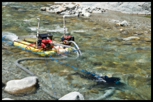
to provide eight(8) gold dredges to operate in various sections of the river
bed.
Throughout the years people of Waitri River area have witnessed
massive scale of gold production and development happening to their area
especially the OK Tedi Mining Project(the largest in Papua New Guinea), and
it has come to their attention that their river banks is rich with alluvial gold
deposits.
Through much consultation work and advice Alluvial Gold Melanesia
Ltd has secured a vital partnership with the Ningerum people and helped
assisted in setting up dredges to the eight (8) clans along the river banks for
alluvial gold production. The company and landowners agreed on a joint
venture and so far the 8 dredges have been delivered.
The old time prospectus used the gold and the pan to follow the
alluvial pathway to the hard rock source. Alluvial Gold Melanesia has
developed an innovative sampling strategy, refining the role of the gold pan,
where the suction dredge is used to bulk sample the gold depositional zones
of the active river channel. The size, physical appearance, inclusions and
position of the gold within the gravel profile still "talks" about the source rocks
just as it did for the old timers. Float rock analysis using XRF equipment, litho
logy identification and geological mapping of creek outcrop provides the
geologist with an understanding of the geological setting and mineralization
styles within the river system. This data rich exploration strategy will be used to
define the mineralised watersheds in river systems across all of the JV's
tenements. These watersheds will be the focus of advanced exploration
programs to locate and define the extent and grade of the mineralisation.
production company based in Port Moresby with operations across the
country's large mining areas. The company was founded in early 2010 and
registered with the Investment Promotion Authority (IPA) of Papua New
Guinea under the companies act. Since its inception, the company started
gathering manpower and equipment to propose small to medium scale
mining operations in Papua New Guinea. It currently has a mining agreement
with the Waitri River Landowners of Ningerum in the Western Province of PNG
to carry out prospective alluvial gold mining work on their river beds. There
are about eight (8) clans altogether along the Waitri river stream which flows
down to the mighty Fly river system, and the purpose of this engagement was
to provide eight(8) gold dredges to operate in various sections of the river
bed.
Throughout the years people of Waitri River area have witnessed
massive scale of gold production and development happening to their area
especially the OK Tedi Mining Project(the largest in Papua New Guinea), and
it has come to their attention that their river banks is rich with alluvial gold
deposits.
Through much consultation work and advice Alluvial Gold Melanesia
Ltd has secured a vital partnership with the Ningerum people and helped
assisted in setting up dredges to the eight (8) clans along the river banks for
alluvial gold production. The company and landowners agreed on a joint
venture and so far the 8 dredges have been delivered.
The old time prospectus used the gold and the pan to follow the
alluvial pathway to the hard rock source. Alluvial Gold Melanesia has
developed an innovative sampling strategy, refining the role of the gold pan,
where the suction dredge is used to bulk sample the gold depositional zones
of the active river channel. The size, physical appearance, inclusions and
position of the gold within the gravel profile still "talks" about the source rocks
just as it did for the old timers. Float rock analysis using XRF equipment, litho
logy identification and geological mapping of creek outcrop provides the
geologist with an understanding of the geological setting and mineralization
styles within the river system. This data rich exploration strategy will be used to
define the mineralised watersheds in river systems across all of the JV's
tenements. These watersheds will be the focus of advanced exploration
programs to locate and define the extent and grade of the mineralisation.
 OUR COMMITMENT
•
To deliver cost effective and easily implemented mining
operation.
•
Economically and environmentally sustainable and ensures
tangible benefits to the people.
•
Strong community participation through our partnership
arrangements
•
To take advantage of the lucrative alluvial mining industry
and expand the joint venture operations given that the
current price of gold is at USD1, 100 per ounce.
•
The joint venture can be able to sustain itself for a longer
period of time financially and diversify into other lines of
business.
•
Employment opportunities as well as other social benefits
will be available for locals
VISION
To operate a highly successful alluvial gold mining venture in Papua New
Guinea.
The one aim of AGM is to focus on small to medium size mining operations
along the river systems of the Western province, and then increase current
prospectus to include other provinces of the country as well. The company's
operations mainly involves prospectus through sampling, mapping, drilling
and geophysics work.
OUR COMMITMENT
•
To deliver cost effective and easily implemented mining
operation.
•
Economically and environmentally sustainable and ensures
tangible benefits to the people.
•
Strong community participation through our partnership
arrangements
•
To take advantage of the lucrative alluvial mining industry
and expand the joint venture operations given that the
current price of gold is at USD1, 100 per ounce.
•
The joint venture can be able to sustain itself for a longer
period of time financially and diversify into other lines of
business.
•
Employment opportunities as well as other social benefits
will be available for locals
VISION
To operate a highly successful alluvial gold mining venture in Papua New
Guinea.
The one aim of AGM is to focus on small to medium size mining operations
along the river systems of the Western province, and then increase current
prospectus to include other provinces of the country as well. The company's
operations mainly involves prospectus through sampling, mapping, drilling
and geophysics work.
 EXPLORATION STRATEGY
Many of today's exploration techniques are model
driven using regional geochemical sampling surveys as the first
pass exploration tool. Typically, the sample is a 10 to 15kg bag
of sand taken from exposed gravel banks in the river. This
sample is then analysed in parts per billion. Stream sediments,
pan concentrates, soil and rock chip samples are often
unreliable because of the small sample size and because the
technique employed is sensitive to environmental factors.
These samples generally do not provide enough information to
help locate ore bodies or focus ground exploration.
The exploration protocol developed by Alluvial Gold
Melanesia is data driven and specifically designed for regions
of high rainfall and erosion rates. The sampling methodology
provides an information rich dataset for all minerals with a
specific density of greater than three i.e. metal sulphides,
silicates and oxides, with the malleability of gold, silver and the
platinum group metals providing extra information.
First Phase - Community and landowner consultation
Community consultation provides information and education
to the landowners about Alluvial Gold Melanesia's exploration
objectives for the river system and manages expectations
about the benefits that will be brought about as a result of the
exploration exercise. The landowners and clan boundaries are
identified and the location and geology of any mining
activities documented. Potential sites for helicopter operations
are investigated and discussed with the community.
Second Phase - Segmentation sampling of major river systems
Gives information on size distribution and morphology of the
heavy minerals in the gravel profile
The mineralogy provides indications on the types of
mineralisation component i.e. gold, platinum and the distance
to source Geochemistry of heavy metals and minerals
Petrology and identification of the float rock population
Both the geochemistry and petrologic studies provide
information on the styles of mineralisation, epithermal,
porphyritic, etc.
Third Phase - Detailed sampling of secondary and tertiary rivers
and streams
This sampling phase identifies the specific river catchments,
which contain the mineralisation.
Results are interpreted in association with air photo/satellite
data, which gives a first pass indication of potential
mineralisation host features - mineralisation is usually
associated with a geological feature, i.e. an intrusive or fault.
Fourth Phase - Geological surveys to evaluate specific targets
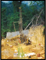
The fourth phase comprises geological mapping, sampling
and drilling to evaluate the extent, grade and style of
mineralisation, factors which enable assessment of the
potential value of the deposit.
EXPLORATION STRATEGY
Many of today's exploration techniques are model
driven using regional geochemical sampling surveys as the first
pass exploration tool. Typically, the sample is a 10 to 15kg bag
of sand taken from exposed gravel banks in the river. This
sample is then analysed in parts per billion. Stream sediments,
pan concentrates, soil and rock chip samples are often
unreliable because of the small sample size and because the
technique employed is sensitive to environmental factors.
These samples generally do not provide enough information to
help locate ore bodies or focus ground exploration.
The exploration protocol developed by Alluvial Gold
Melanesia is data driven and specifically designed for regions
of high rainfall and erosion rates. The sampling methodology
provides an information rich dataset for all minerals with a
specific density of greater than three i.e. metal sulphides,
silicates and oxides, with the malleability of gold, silver and the
platinum group metals providing extra information.
First Phase - Community and landowner consultation
Community consultation provides information and education
to the landowners about Alluvial Gold Melanesia's exploration
objectives for the river system and manages expectations
about the benefits that will be brought about as a result of the
exploration exercise. The landowners and clan boundaries are
identified and the location and geology of any mining
activities documented. Potential sites for helicopter operations
are investigated and discussed with the community.
Second Phase - Segmentation sampling of major river systems
Gives information on size distribution and morphology of the
heavy minerals in the gravel profile
The mineralogy provides indications on the types of
mineralisation component i.e. gold, platinum and the distance
to source Geochemistry of heavy metals and minerals
Petrology and identification of the float rock population
Both the geochemistry and petrologic studies provide
information on the styles of mineralisation, epithermal,
porphyritic, etc.
Third Phase - Detailed sampling of secondary and tertiary rivers
and streams
This sampling phase identifies the specific river catchments,
which contain the mineralisation.
Results are interpreted in association with air photo/satellite
data, which gives a first pass indication of potential
mineralisation host features - mineralisation is usually
associated with a geological feature, i.e. an intrusive or fault.
Fourth Phase - Geological surveys to evaluate specific targets
The fourth phase comprises geological mapping, sampling
and drilling to evaluate the extent, grade and style of
mineralisation, factors which enable assessment of the
potential value of the deposit.